|
|
KISSIMME RIVER INFORMATION GUIDE
FLORIDA FRESHWATER FISHING - THE KISSIMMEE RIVER:
A Lesson In 'Don't Mess With Mother Nature'
Jim Porter
(AUTHOR'S NOTE: When you read this article, you should recognize that it will be obsolete in a few years. The Kissimmee River, as it is today, will no longer exist. So, what you find in this material will actually become a piece of history someday, for it will describe something that was, but no longer is.
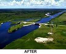
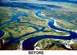 Prior to 1962, the Kissimmee River was a natural flowage, with all the beauty and wildlife Nature could bestow. Today, it is sometimes called 'The Big Ditch'. That term fits well, because Man decided He could do better than Nature and turned the Kissimmee River into what is basically a manmade canal. (Note the 'before' and 'after' photos.)
But, all that will change yet again. Finding that He really ISN'T smarter than Mother Nature, Man will now restore the Kissimmee River to its original state.
 The first section of the article is the history of the Kissimmee River, as we know it today. Then, we move into a tour of the river and its present fishing opportunities. The fishing remains excellent to date.)
HISTORY
In 1948, Congress authorized the U.S. Army Corps of Engineers to initiate construction of the Central & Southern Florida Project for flood control and protection. In 1954, Congress specifically authorized the Kissimmee River portion of the project, which was planned and designed from 1954 to 1960. Between 1962 and 1971, the Kissimmee River was channelized and transformed into a series of impounded reservoirs (Pools A-E). Inflow from the upper basin was regulated by six water control structures (S-65s). Water control structures and canals were built in the upper lakes region, which allowed regulation of water flow within and between the lakes of the upper basin.
The physical effects of channelization, including alteration of the system's hydrologic characteristics, largely eliminated river and floodplain wetlands and degraded fish and wildlife values of the Kissimmee River ecosystem. The meandering river was transformed into a 56-mile-long, 30-feet-deep, 300-feet-wide canal. Excavation of the canal and deposition of the resulting spoil eliminated approximately 35 miles of river channel and 6,200 acres of floodplain
wetland habitat. Transformation of the river-floodplain ecosystem into a series of deep impoundments drained much of the floodplain, eliminated historical water-level fluctuations, and greatly modified flow characteristics. Approximately 26,000-31,000 acres of pre-channelized floodplain wetlands were drained, covered with spoil, or converted into canal. The floodplain at the lower end of each pool remained inundated, but pre-channelization water level fluctuations
were eliminated. Low-and no-flow regimes in remnant river channels resulted in encroachment of vegetation, especially floating exotics (such as water lettuce and water hyacinth] to the center of the river channel. Senescence and death of encroaching vegetation covered the shifting sand substrate of the historic channel with thick accumulations (up to 3 feet) of organic matter, greatly increasing the biological oxygen demand of the system.
River channelization and degradation of the floodplain let to severe impacts on the system's biological components. By the early 1970s, floodplain utilization by wintering waterfowl declined by 92%. Wading bird populations, a highly visible component of the historic system, declined and were largely replaced by cattle egrets, a species generally associated with upland, terrestrial habitats. Low-and no-flow regimes in the canal and remnant river channels resulted in chronically low dissolved oxygen levels and sport fish species like largemouth bass were being replaced by species tolerant of low dissolved oxygen regimes (such as Florida gar and bowfin). Stabilized water levels and reduced flow also eliminated river-floodplain interactions. Influx of organic matter, invertebrates, and forage fishes to the river from the floodplain during periods of water recession was eliminated. Stabilized water levels also largely eliminated adult spawning and foraging habitat, as well as larval and juvenile refuge sites for fish on the floodplain.
The Kissimmee River Restoration Project was authorized by Congress in the
1992 Water Resources Development Act. The project will restore over 40 square
miles of river/floodplain ecosystem including 43 miles of meandering river channel and 27,000 acres of wetlands. The restoration project will be jointly implemented and cost-shared by the South Florida Water Management
District (SFWMD) and US Army Corps of Engineers (USCOE). Which means you and I, as taxpayers, will pay for it.
Full details on the Kissimmee River Restoration Project can be found on the Web at www.sfwnd.gov/org/erd/krr/.
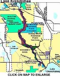 The upper Kissimmee River drainage basin begins near the cities of St. Cloud and Kissimmee in the central Florida peninsula. A series of small lakes to the East of St. Cloud (lakes Mary Jane, Hart, Alligator, Gentry) and East Lake
Tohopekaliga actually form the northern-most starting point of the river system. Flowing to the South, the drainage gradually blends with `Big' Lake Tohopekaliga, lakes Cypress and Hatchineha, and their feeder systems to form the Kissimmee River.
The upper Kissimmee River drainage basin begins near the cities of St. Cloud and Kissimmee in the central Florida peninsula. A series of small lakes to the East of St. Cloud (lakes Mary Jane, Hart, Alligator, Gentry) and East Lake
Tohopekaliga actually form the northern-most starting point of the river system. Flowing to the South, the drainage gradually blends with `Big' Lake Tohopekaliga, lakes Cypress and Hatchineha, and their feeder systems to form the Kissimmee River.
For the purists among you, the drainage is first recognized as the Kissimmee River when it exits from Lake Hatchineha. From Hatchineha, the river flows into massive Lake Kissimmee.
At the southern-most end of sprawling Lake Kissimmee, we find the crossing of Highway 60, a major East-West artery across the state. The namesake river passes under this highway and exits through Lock S-65. A good commercial
marina, store and launch area is found just to the West of the lock and on the North side of Highway 60. S-65 is the second of seven navigable locks on the drainage and river system, with the first being S-61 at the lower end of Big
Lake Tohopekaliga.
Each lock is 30 by 60 feet and has a low-end depth of at least six feet. At each of the upper and lower lock entrances, the boater will find a signal horn to alert the lock tender of a request for passage. Upon signal from the tender, or when the signal light turns green, enter the lock slowly and with no wake. On each side of the lock interior, you will find safety lines hanging down. These are to be
used to hold your boat in place and stable as the water level of the lock is either lowered or raised. DO NOT tie these lines to the boat; instead, hold them by hand and preferably near the center of the boat. While in the lock, the motor
should be stopped and no smoking or refueling is allowed. Boats exiting from the locks ALWAYS have the right-of-way, and no entrance or exit is permitted while the lock gates are still in motion.
As you enter this lock, as well as all others on the river system, you will note a public launch ramp just above and to the West side. At this particular location, there is also a launch ramp in the rear of a small canal below the lock.
Below this lock, you will note the man-made profile of the Kissimmee River, which will exists until it reaches Lake Okeechobee some 56 miles to the South. In effect, a large canal was dug along the trace of the original Kissimmee River. (In fact, the South Florida Water Management District refers to it as Canal 38.) The result is a series of long, straight sections of water, separated by a few very gentle bends. The adjacent banks are generally 2-4 feet high, with grass and/or trees. Some sections have rather high banks (actually levees) formed from the dirt dug from the man-made channel, while those at lower elevations will be bordered by natural forests. The original Kissimmee River channel meanders back and forth across the new `Big Ditch', forming numerous `oxbows'.
The Kissimmee River section between locks S-65 and S-65A is locally referred to as Pool `A'. The first old river oxbow, below the lock and on the right, is a classic example of ideal bass-producing structure. Look at the upper (upstream) opening closely and you will find a hump on its upstream corner, an irregular and rough drop-off across the mouth, and good hydrilla growth in the shallows just behind the dropline. Fish this one closely, pay attention to its details and features, note where the bass are found, and you should have no trouble with the others.
The next old channel going off to the right leads to a very modern and fully equipped resort and camping area called `River Ranch'. It has all facilities and is very nice. (It is also the only one of its type along the river.)
Both the upper and lower openings of the River Ranch `oxbow' are good, particularly the upper one. Directly across from this upper opening is a similar one on the East shoreline. It also produces bass well. In all three of these, concentrate on the rough bottom you'll find in the middle of the opening and at the edge of the drop.
Approximately halfway between locks S-65 and S-65A, you will note a series of high dirt mounds begin on the West side. Just as these mounds begin, what appears to be one of the old river oxbows makes its intersection on the same side. With a little exploration, you will find that this is NOT a part of the old river trace, but instead is a canal leading in from the adjacent Kicco Wildlife Management Area. The only significance of it being a canal is that any run-off of
local rains moves directly down the canal into the river, and the waters, therefore, carry significant amounts of silt. The further significance of this is that a very predominate slit bar has built up at the downstream corner of the canal mouth. In fact, it stretches its way nearly across the new river channel. Look with your depth sounder and you will find 12-18 feet of water where there should be 30-35. A deep Bagley DB-III and a Carolina-rigged worm will take a limit here quite often.
The last old river oxbow prior to lock S-65A has some good depth in it, particularly midway along where an old house is located. Pitch plastic worms into the cover along the western shoreline and work them very slowly.
Below lock S-65A, we enter Pool `B'. It is similar to `A', except for some backwater areas at its upper end and a series of three `weirs' about mid-way down.
The backwater areas are strips of water between the West shoreline and some dirt mounds along the edge of the river. What these were intended to be is anyone's guess, but they provide good spawning and holding areas for bass,
Bluegills and speckled perch.
The weirs previously mentioned were installed to restrict current flow, cause the water levels to rise slightly behind them, and force some water to exit into the
old river oxbows and surrounding marshes. Navigating the weirs can be dangerous if the waters are rising and the current is strong. Their openings are small and the swirling currents quite strong. Each weir was deliberately built
where an old river oxbow was available to provide alternate passage. It is a good idea to use the by-pass under strong current conditions.
Pool `B' offers exceptionally good bass angling at the mouths of some of the oxbows. In this pool, wild shiners are a favorite method of fishing for trophies. Look for those locations with good growths of pads at the corners and fish
the shiners in and under them.
Pool `C', below Lock S-65B, is very similar to Pool `B', but has no weirs. Pool `C' also has some very large and deep oxbows which are excellent locations to fish spinner baits. The first oxbow below the lock, and on the West side, is my
favorite. Go approximately a quarter mile into it and you will find some deep-water bends and good grass beds. The last oxbow on the East shore, a mile or so above the next lock (S-65C), is a producer of trophy bass. Fish the shiners
or artificial lures directly in the center of the mouth and at the edge of the drop-off into deep water. During March-May timeframe, watch for surface schooling bass in this location.
Passing through Lock S-65C and into Pool `D', we find few of the familiar oxbows until we pass beneath the Highway 98 bridge at the community of Ft. Basinger. Approximately one mile South of this bridge, and on the East side of the river, an old oxbow will be found. This one is one of the better places for a limit of bass. A good current is usually flowing through it. Take your time and find the narrow
places where the current is moving at a good pace. Let the current move your boat along as you flip plastic worms into the cover on both sides. Be sure to use at least 20 pound-test line here, as the fish are often large.
Shiner fishing is good in the other oxbows of Pool `D'.
Pool `E', below the next lock (S-65D), has a number of very productive oxbows. We have had more luck with artificials in this pool than with the wild shiners. And, a distance, on the main channel, of 20 yards above and below the oxbow openings has proven very productive for 4 and 5 pound bass using plastic worms. The shorelines just above and below the Highway 70 bridge are also good. Watch your depth sounder for indications of a submerged treetop under
the bridge. It is a bit deep, but will hold bass in the winter months. Consider vertical jigging a spoon over it.
The last lock on the Kissimmee River is S-65E. The water below it leads directly to Lake Okeechobee. This stretch is lined with thin grass, is very deep and the banks drop very sharply. A deep crank plug pulled along the outside of the grass line can often work well. If you use a plastic worm, it must be fished in the grass, in that the water is 20 feet deep at the edge of it. The area in and around the entrance into Lake Okeechobee becomes shallow and grassy. Normal shallow water cover fishing techniques are applied here.
Just below Lock S-65E, and on the West side, is the entrance to a small feeder canal. Look for a sandbar at the canal mouth. It will be a bit deep, but it is there. Use a jig or heavily weighted worm. This is a fine location when current is moving well in either the canal or the Kissimmee River.
Now that we have had a tour of the lower Kissimmee River, let's look at some general aspects of this fine fishing area.
The new channel is rather bland in its topography, with sloping banks and a 30-35 foot center depth. For the angler who likes to `take a lure and throw it at the bank', there are approximately 112 miles of that shoreline available in the channel. And, it produces some pretty fair fishing, too. Small bass are easily taken by those casting plastic worms and small spinners along the grass and pads. Fly rod enthusiasts will find excellent bluegill fishing available during the months of April through August. In fact, if the intent is to `just catch fish', the shoreline of the man-made channel is tough to beat.
The open water of the channel provides year-round speckled perch angling second to none (except possibly the January-March run on Lake Okeechobee). An interesting point, however, is that most anglers have yet to tap this fabulous
resource. The majority of Florida anglers are accustomed to shallow waters and do not appear to adapt well to the 30 foot range of the `Big Ditch'. Here's what we have found:
- Feb-Mar.: Spawning time; look for the speckled perch to be out of the areas of current flow, usually in the old riverbed.
- Apr-Jul.: 10-12 feet deep; in the center of the channel.
- Jul-Dec.: 18-25 feet deep; in the center of the channel.
- Jan-Feb.: 8-10 feet deep; along the drop-offs (on both sides)
Jigs and small spinners work well above 12 feet. Below that depth, use only live minnows. Keep in mind that the deeper you fish, the slower your retrieve or drifting speed should be.
Intermittently, the old riverbed meanders back and forth across the new channel, with some portions remaining navigable and others not. We previously referred to these as oxbows. These intersections provide the only real `structure', or topography variances, in the lower Kissimmee River.
At normal water levels, the depth in the old channel traces is approximately 6-8 feet. This will vary somewhat, based on the current that may still pass through an individual trace and the resultant amount of silting that has occurred over the years. Also, if you will recall, we indicated that the new channel has a depth of 30-35 feet. At the point that the old and new Kissimmee River channels
converge, then, there must obviously be a major drop-off. And, it is this single feature, which provides the key to the excellent and repetitive bass angling experiences.
In evaluating these channel intersections, the first step is to make slow passes across the area of the drop-off and, with a depth sounder, locate the breakline. Note whether it runs straight, or is irregular. Also, note any protrusions, particularly at the up- and down-stream corners of the old channel mouth. There will often be bars and shallow humps at the corners of these intersections.
Additionally, look for rock piles or lodged drift along the upper edge of the drop-off. The former may have been created during the digging of the main channel, while the latter simply washed in with an earlier high-water condition. In some cases, brush tops may have been placed by local anglers.
Also, examine the old channel for the first 20-30 yards in from the drop-off. Very often, we find hydrilla beds in the 6-8 foot range at these locations.
The first lure employed should be a diving crank plug, selected precisely for the depth being fished. In general, this type lure should always be in close contact with the bottom as it is retrieved.
Next, select a plastic worm or jig. If there happens to be significant current flow present, a heavily weighted Carolina rig is highly recommended, in that it provides for better bottom contact and `feel' of the lure.
Work any bars or high spots located on the corners of the intersection. Then, go to the drop-off along the intersection mouth. Lastly, switch to a free-running,
vibrating crank plug (such as a Rat-L-Trap) and a lightly weighted plastic worm and cover the hydrilla, or other vegetation inside the mouth of the intersection.
The interior confines of the old channel traces often provide good fishing. Additionally, much of the spawning of all the species takes place in these locations. Those which are open to the main channel at both ends and permit current flow are usually best, in that they have some reasonable depth and do not become stagnant.
Launch ramps are available on the West side of each lock. Facilities are available only at River Ranch Resort and at Lake Okeechobee.
Good maps of the Kissimmee River and its drainage basin are available by writing the South Florida Water Management District, PO Box 24680, West Palm Beach, Fl. 33416-4680.
|
Recommended sites by The Fishin' Tipster |
A common question that we get: "Is there somewhere close to get bait and tackle?" This is where we get our bait.

Pete and Tina Heinz / 9 South Mulberry St. / Fellsmere, FL 32948 / 772-571-9855
Get your site listed here
Let us help you drive more targeted traffic to your site.
|


Rank our Site
©Copyright 2001-07 All rights reserved by Jim Porter, any reproduction, quotation or other use of this site or its elements is prohibited without the express written permission of Jim Porter
|
|
|
Protect your eyes from the sun on your next fishing trip. Buy
[an error occurred while processing this directive]
or
[an error occurred while processing this directive]
at TV Products 4 Less.
|
 |
 |
 |
 |
 |
 |
 |
 |
|
Join Mailing List
|
|
|


